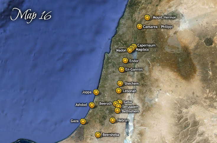
Map 16: Travels of Jesus through Palestine to Mount Hermon July 19, 25 A.D. ~ October 1, 25 A.D. Map 15 | Maps Index | Map 17 Image Location Reference Google Map Link Joppa July 19 ~ 134:7.4 32.04216457186249,34.7504848911293 Ashdod 134:7.4 31.80140404045039,34.65395019138941 Gaza 134:7.4 31.498633333333,34.4622 Beersheba 134:7.5 31.2493965508311,34.79059401175636 Hebron 134:7.5 31.52467912564482,35.10738400026286 Bethlehem 134:7.5 31.70515016823694,35.21122465309352 Jerusalem 134:7.5 31.777766666667,35.230866666667 Beeroth 134:7.5 31.825566666667,35.177766666667 Lebonah 134:7.5 32.068866666667,35.241133333333 Schechem 134:7.5 32.20315349058198,35.27366812744823 Geba 134:7.5 31.8525,35.2622 En-Gannim 134:7.5 32.45905289551778,35.30266277114077 Endor 134:7.5 32.62648833183192,35.38382380295226 Madon 134:7.5 32.8158,35.481066666667 Magdala 134:7.5 32.84673276947773,35.52445049880779 Capernaum 134:7.5 32.88049529963555,35.57293371387502 Caesarea - Philippi 134:7.5 33.24832420068191,35.69338967245574 Mount Hermon August 10 - Sept. 15 ~ 134:7.7 33.41046407715493,35.85678303381869 Book traversal links for Map 16: Travels of Jesus through Palestine to Mount Hermon